Sunspot Groups with Largest Areas (1874-2016)*
Sunspot Groups with Areas Exceeding 2500 MSH
- MSH stands for millionths of solar hemisphere; 1000 MSH corresponds to 23.8 times the cross-sectional area of Earth.
- The regions that re-appeared by the rotation (about one month period) of the Sun are regarded as an identical region, and its maximum area over the life of the region is used in the ranking of areas.
- [* No sunspots with an area greater than 2500 MSH have appeared since 2016, and the tables in this page are still valid (2024).]
Data Sources
-
1874-1954 Royal Greenwich Observatory (1955), Sunspot and Geomagnetic Storm-Data Derived from Greenwich Observations 1874-1954
The dates of maximum area were taken from ftp://ftp.ngdc.noaa.gov/STP/SOLAR_DATA/SUNSPOT_REGIONS/Greenwich/ 1955-1976 Kopecký and Kotrc , Bull. Astron. Inst. Czechosl. 25, 171, 1974
Kopecký, Bull. Astron. Inst. Czechosl. 33, 65, 1982
The dates of maximum area were taken from ftp://ftp.ngdc.noaa.gov/STP/SOLAR_DATA/SUNSPOT_REGIONS/Greenwich/ 1977-2016 Royal Observatory, Greenwich - USAF/NOAA Sunspot Data (NASA/MSFC)
| 1874-1954 | Royal Greenwich Observatory (1955), Sunspot and Geomagnetic Storm-Data Derived from Greenwich Observations 1874-1954 The dates of maximum area were taken from ftp://ftp.ngdc.noaa.gov/STP/SOLAR_DATA/SUNSPOT_REGIONS/Greenwich/ |
| 1955-1976 | Kopecký and Kotrc , Bull. Astron. Inst. Czechosl. 25, 171, 1974 Kopecký, Bull. Astron. Inst. Czechosl. 33, 65, 1982 The dates of maximum area were taken from ftp://ftp.ngdc.noaa.gov/STP/SOLAR_DATA/SUNSPOT_REGIONS/Greenwich/ |
| 1977-2016 | Royal Observatory, Greenwich - USAF/NOAA Sunspot Data (NASA/MSFC) |
In Order of Areas
- In the 'Data' column, I means white-light images, D means sunspot drawings.
- ■ means an image or a drawing of the region is available. If no data are found on the day of maximum area, data of a nearby date are provided. The date will show up when the cursor is on the mark.
□ means no data are available.
Rank
Date of
Maximum Area
Area
(MSH)
Region Name
Note
Data
I D
1
(
(
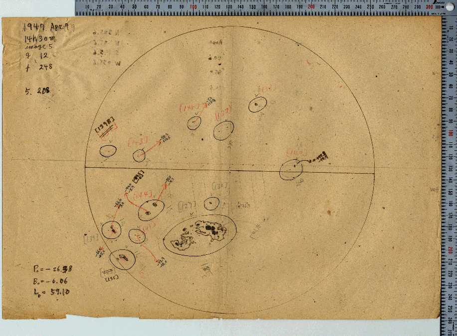
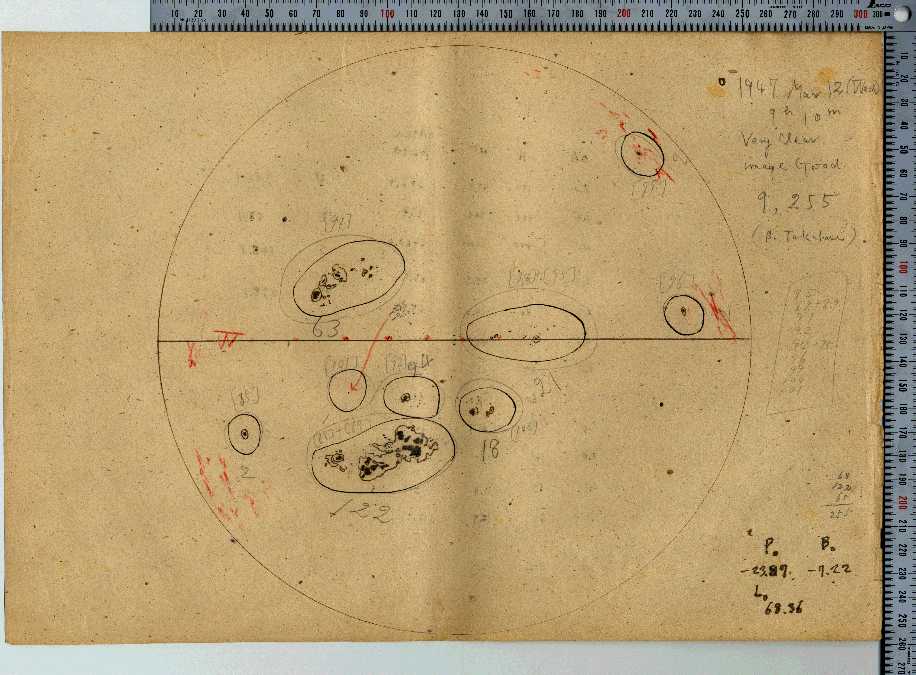
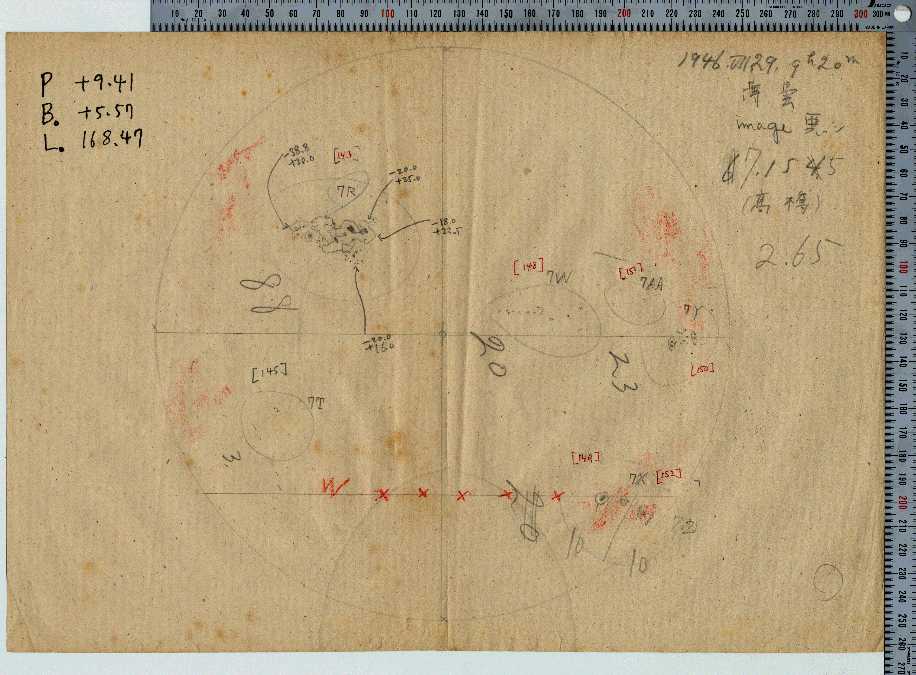
1947
1947
1947
4
3
2
8
12
10
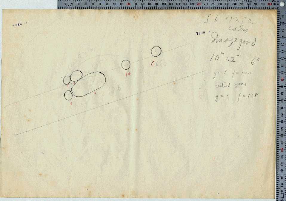
6132
4554
2944
RGO
RGO
RGO
14886
14851
14813
) one rotation before
) two rotations before
□ ■
□ ■
□ ■
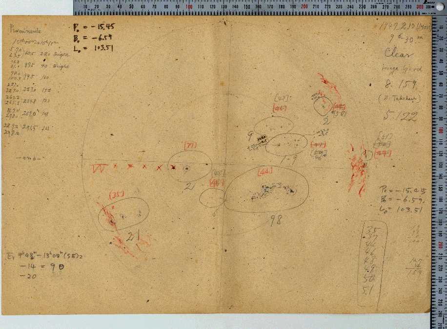
2 1946 2 7 5202 RGO 14417 □ ■
3
(
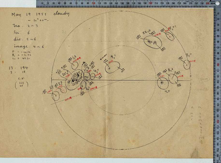
1951
1951
5
4
19
19
4865
2553
RGO
RGO
16763
16745
) one rotation before□ ■
□ ■
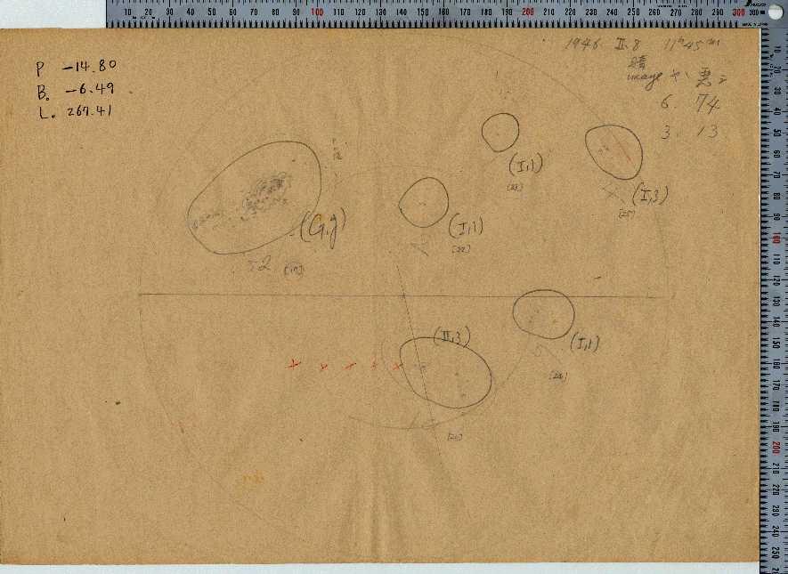
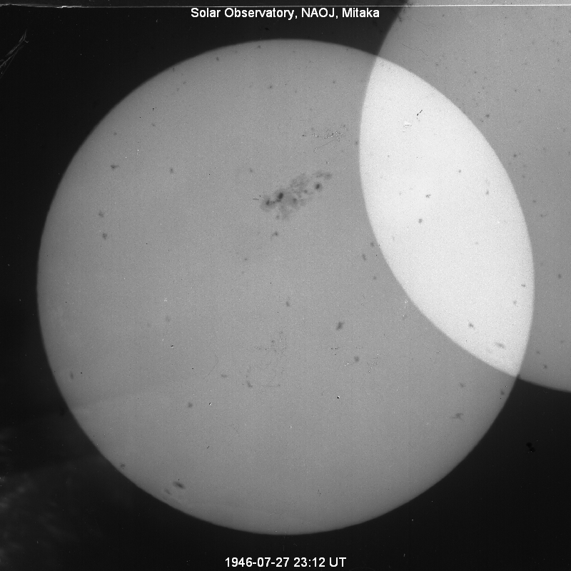
4 1946 7 29 4720 RGO 14585 ■ ■
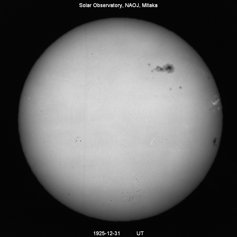
5(
1926
1925
1
12
19
31
3716
2934
RGO
RGO
9861
9830
) one rotation before■ □
■ □
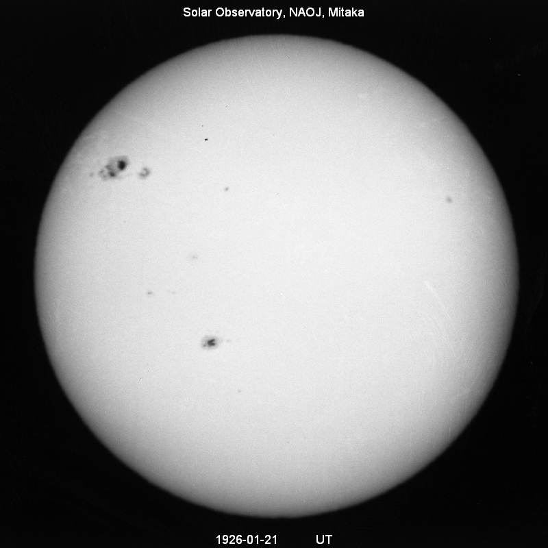
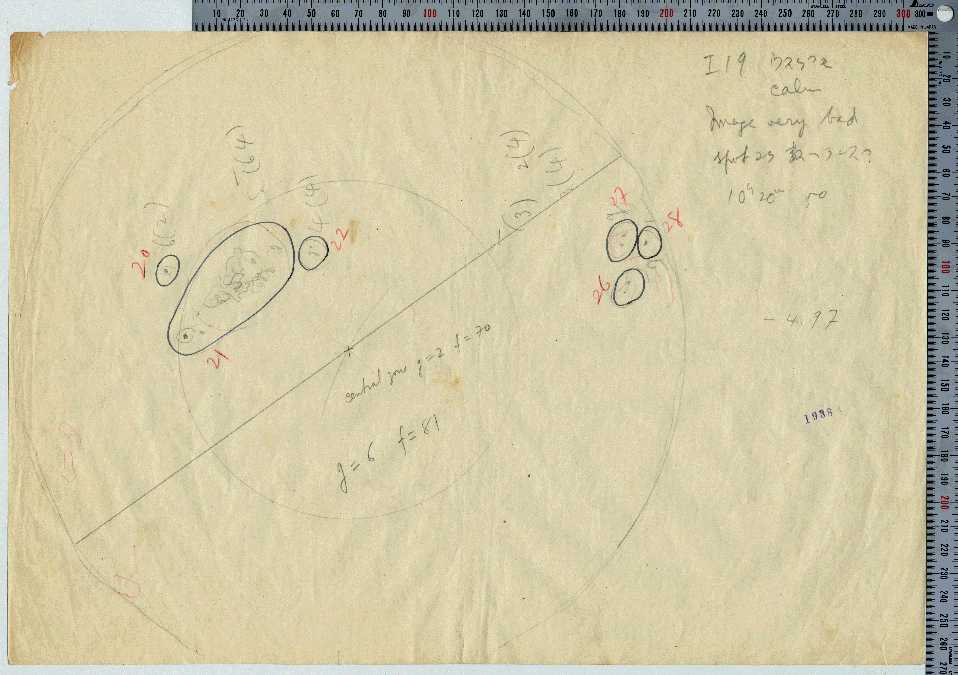
6 1938 1 21 3627 RGO 12673 □ ■
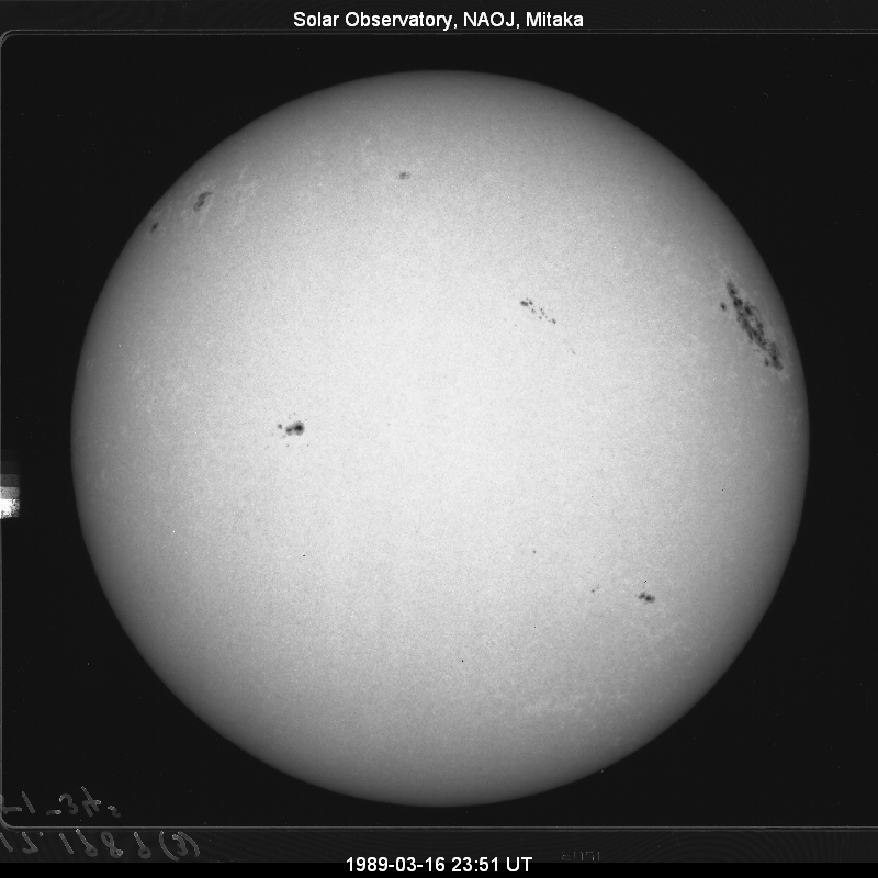
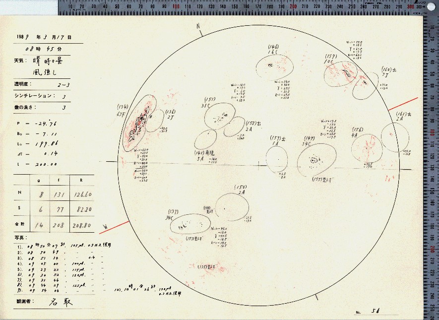
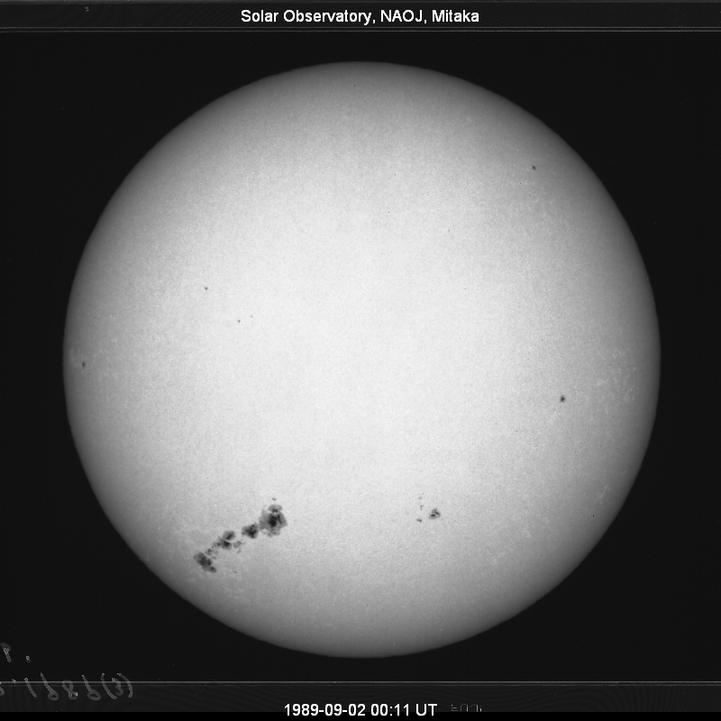
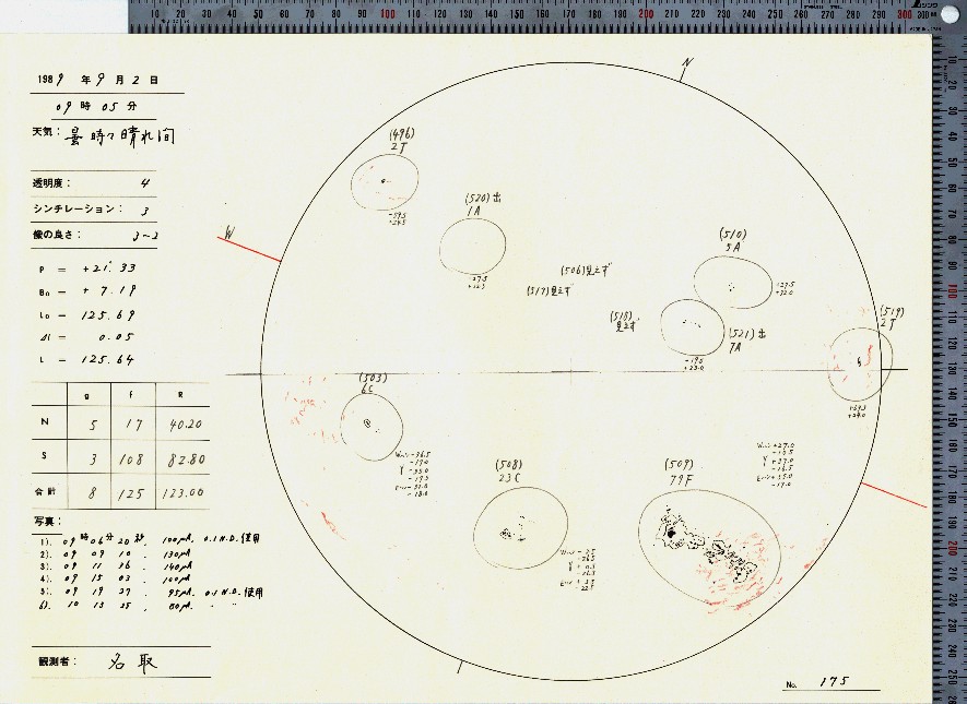
7 1989 3 17 3600 NOAA 5395 ■ ■
8 1917 2 14 3590 RGO 7977 □ □
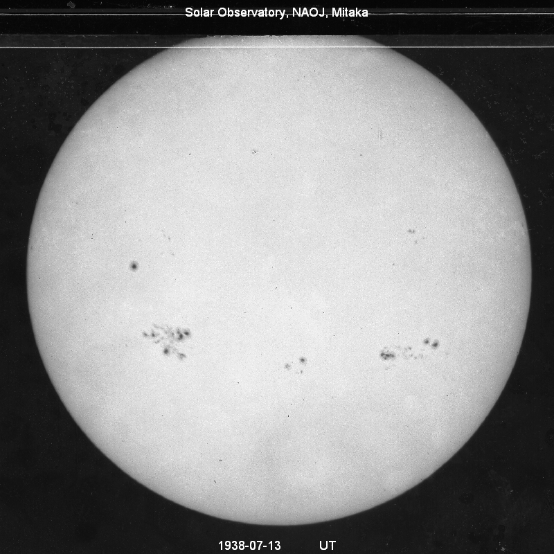
9 1938 7 20 3379 RGO 12902 ■ ■
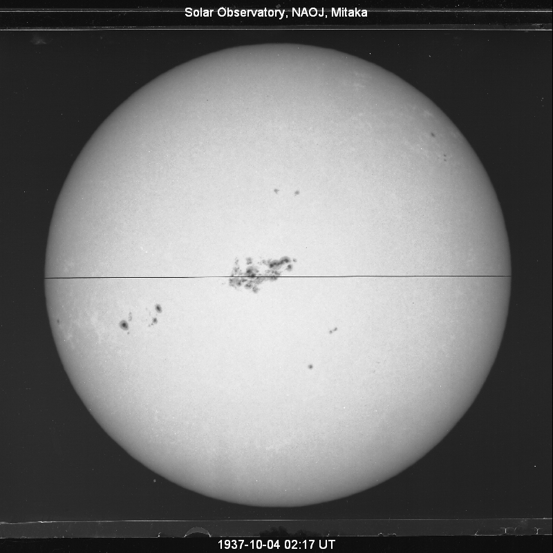
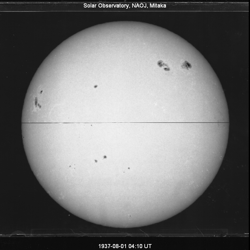
10 1937 10 5 3340 RGO 12553 ■ □
11 1905 2 2 3339 RGO 5441 □ □
12 1937 7 28 3303 RGO 12455 ■ □
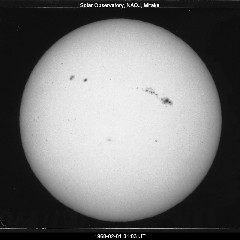
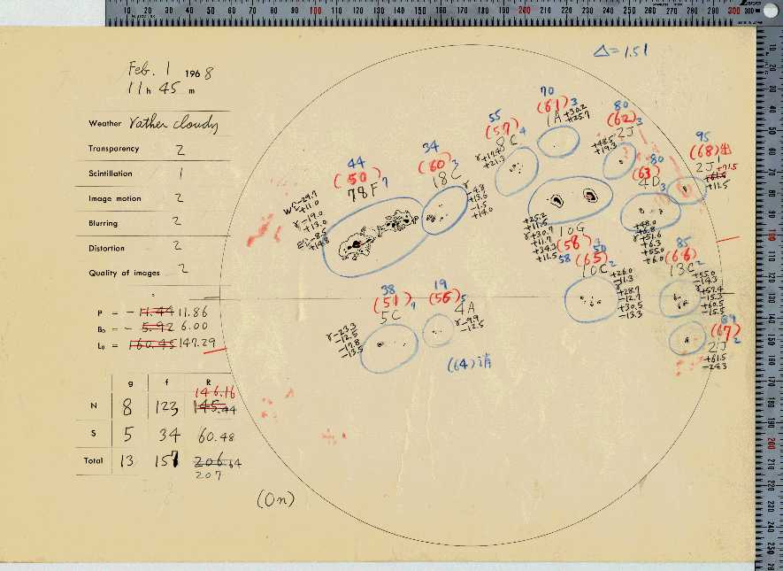
13 1968 2 1 3202 RGO 21482 ■ ■
14 1917 8 9 3178 RGO 8181 □ □
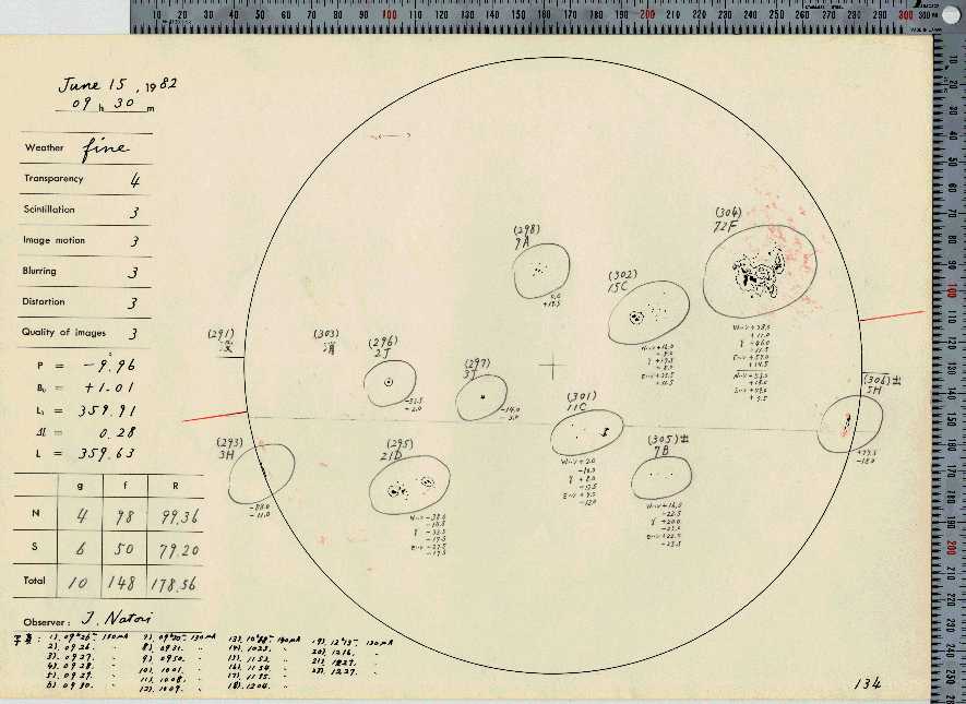
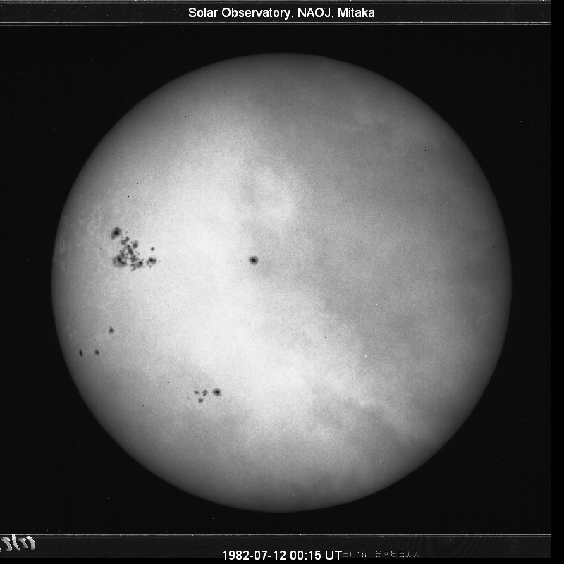
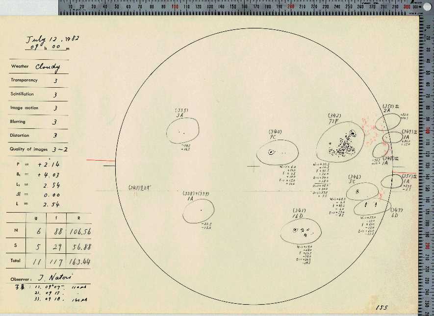
15
(
1982
1982
6
7
14
12
3100
2870
NOAA
NOAA
3776
3804
) one rotation after■ ■
■ ■
16 1941 9 21 3088 RGO 13937 □ ■
17 1989 9 3 3080 NOAA 5669 ■ ■
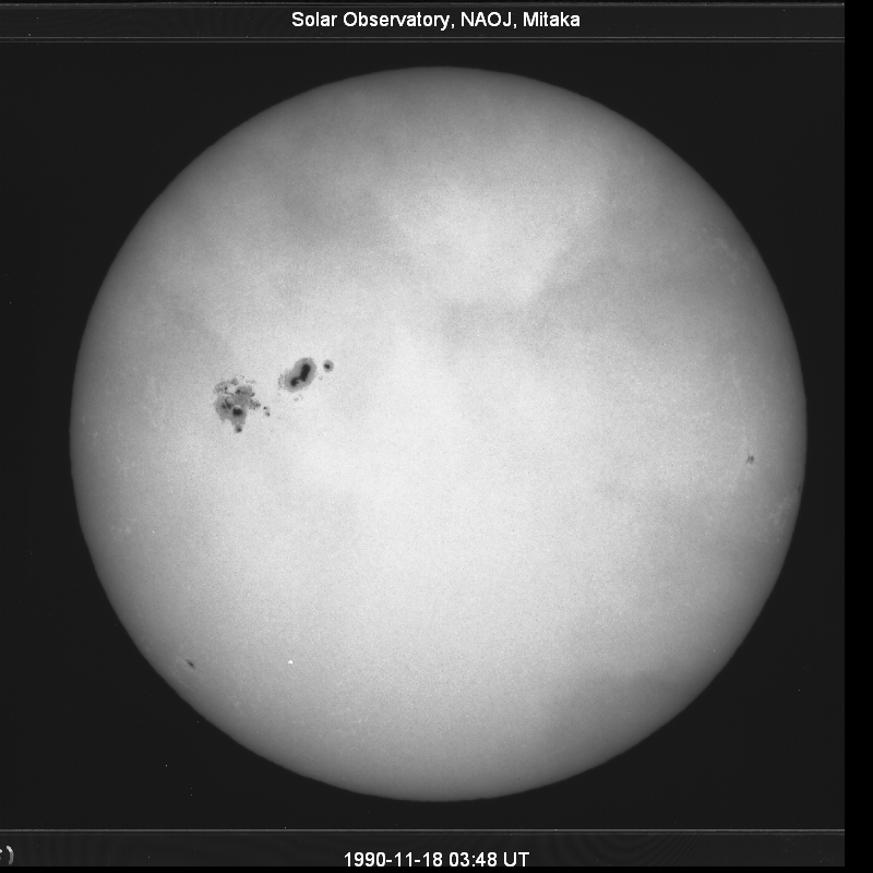
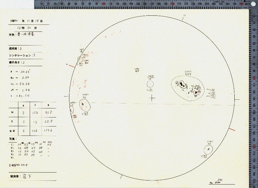
17 1990 11 18 3080 NOAA 6368 ■ ■
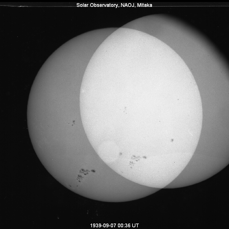
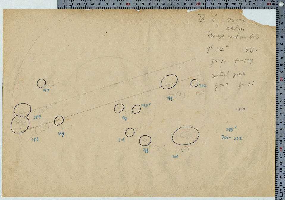
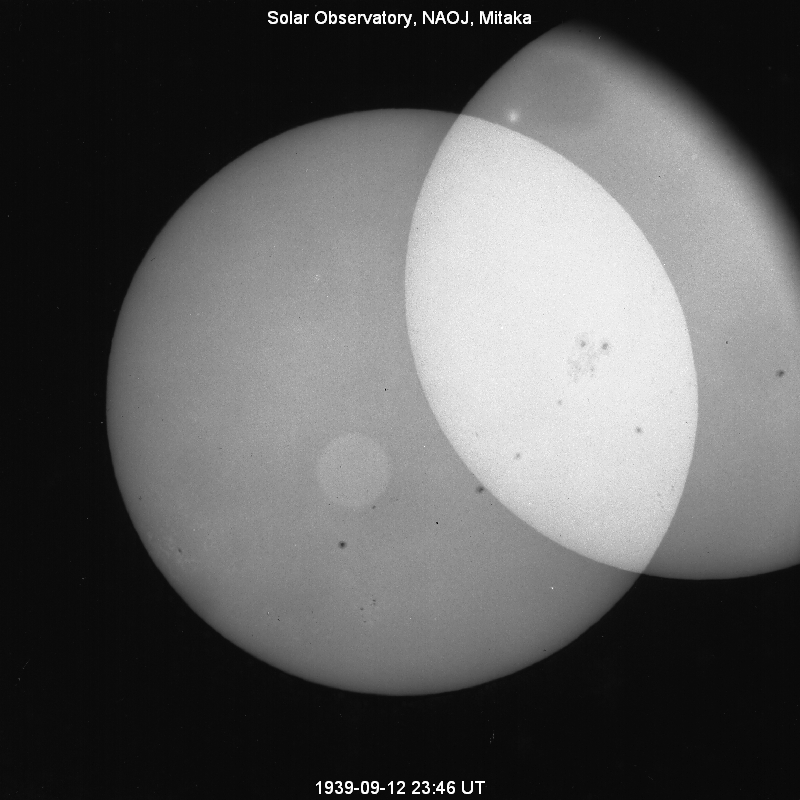
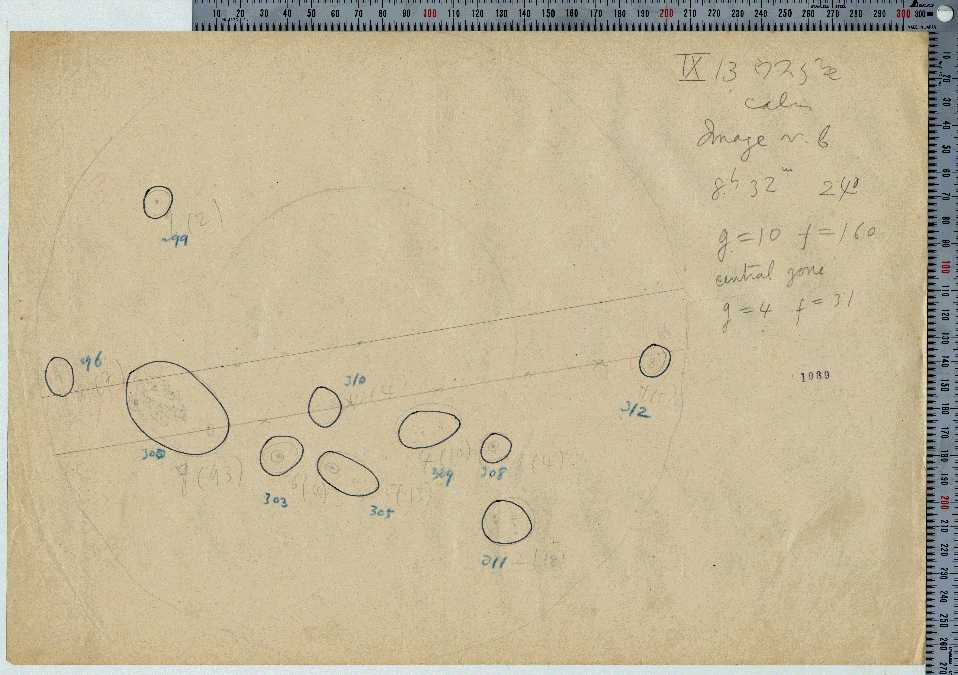
19 1939 9 6 3054 RGO 13394 ■ ■
20 1892 2 10 3038 RGO 2421 □ □
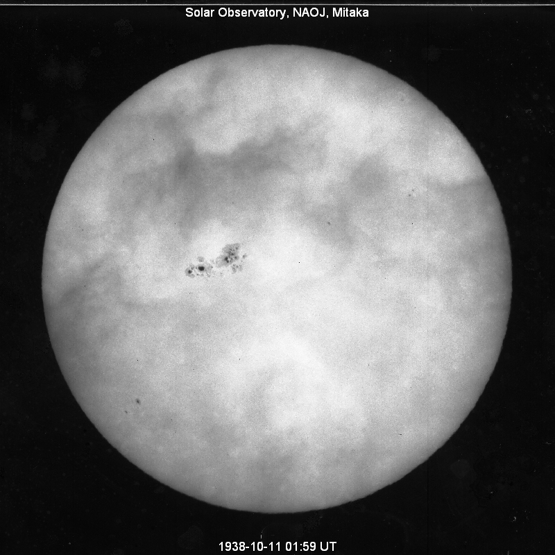
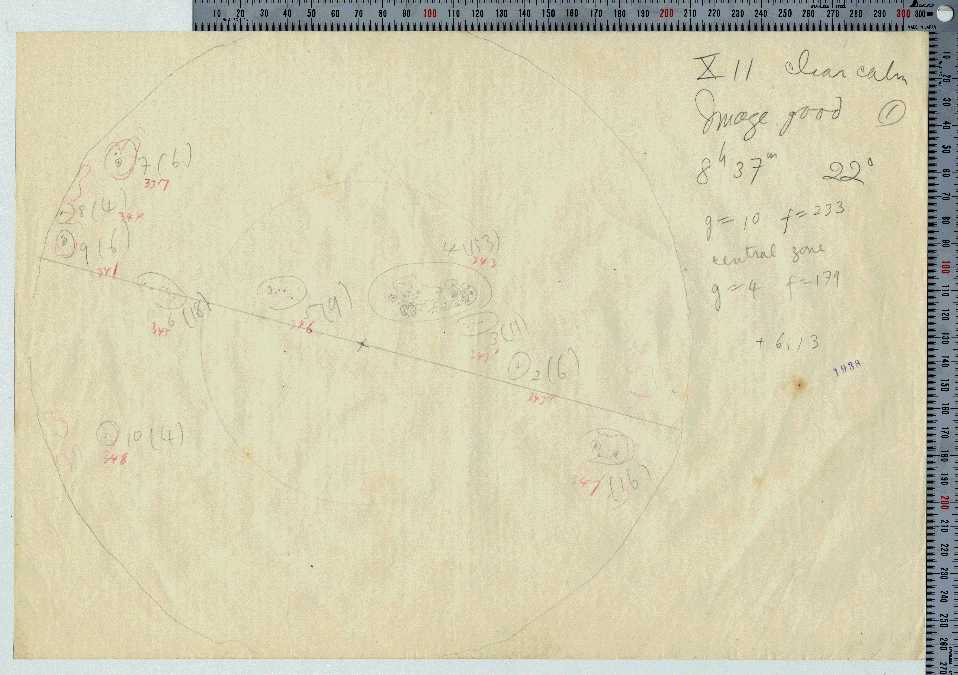
21 1938 10 12 3003 RGO 13024 ■ ■
22 1905 10 19 2995 RGO 5682 □ □
23 1939 9 13 2993 RGO 13405 ■ ■
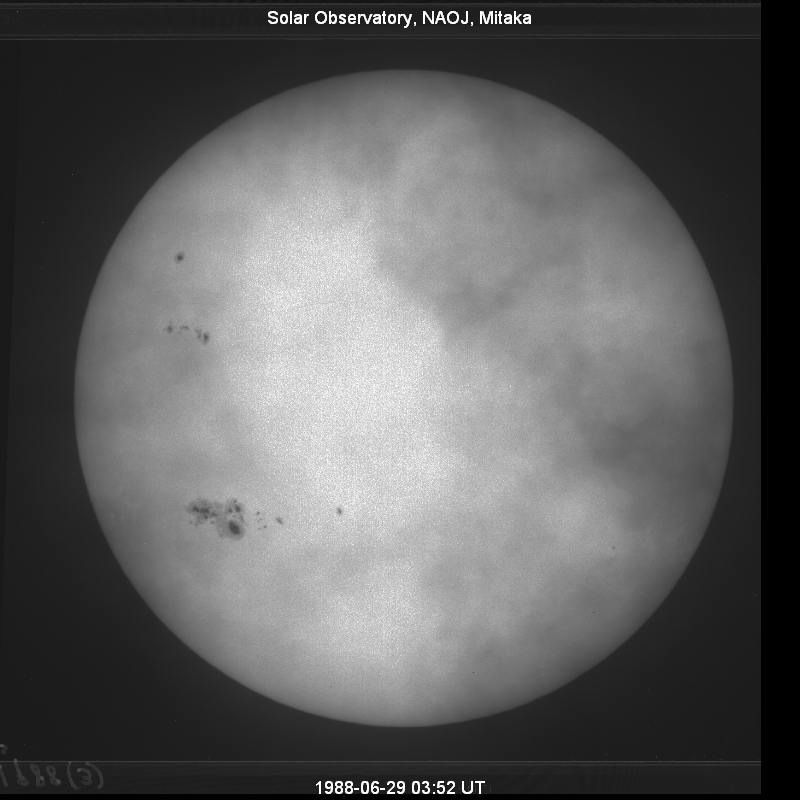
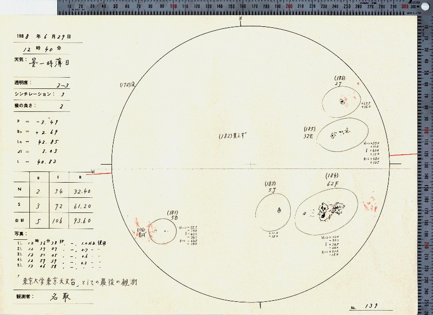
24 1988 6 29 2900 NOAA 5060 ■ ■
25 1940 1 6 2860 RGO 13502 □ ■
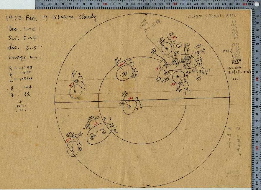
26 1950 2 16 2856 RGO 16410 □ ■
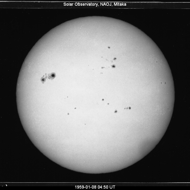
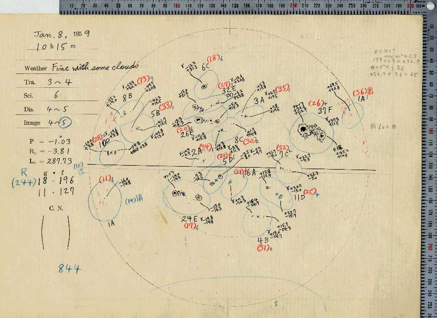
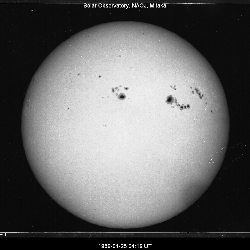
27 1959 1 8 2805 RGO 19109 ■ ■
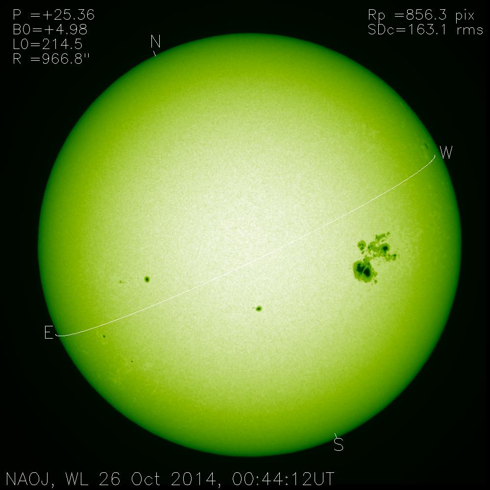
28 2014 10 26 2750 NOAA 12192 ■ ■
29 1897 1 8 2743 RGO 4497 □ □
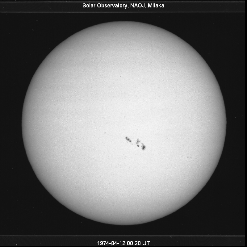
30 1974 4 16 2706 RGO 23491 ■ ■
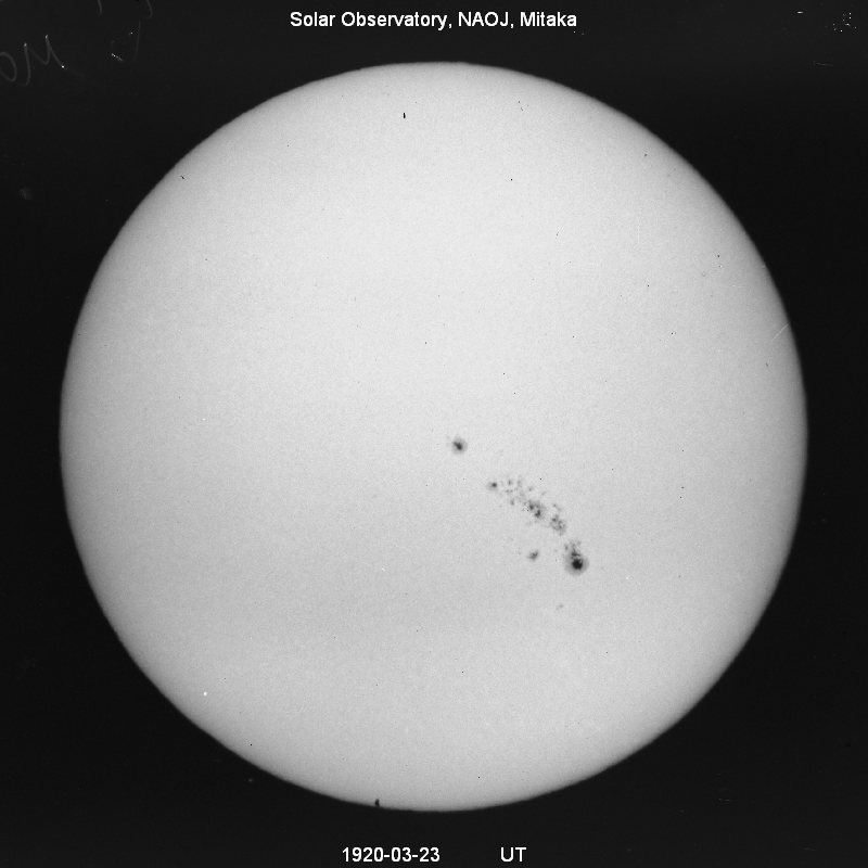
31 1920 3 23 2690 RGO 9143 ■ □
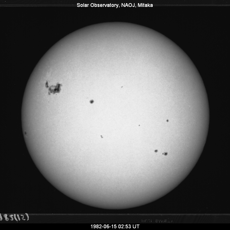
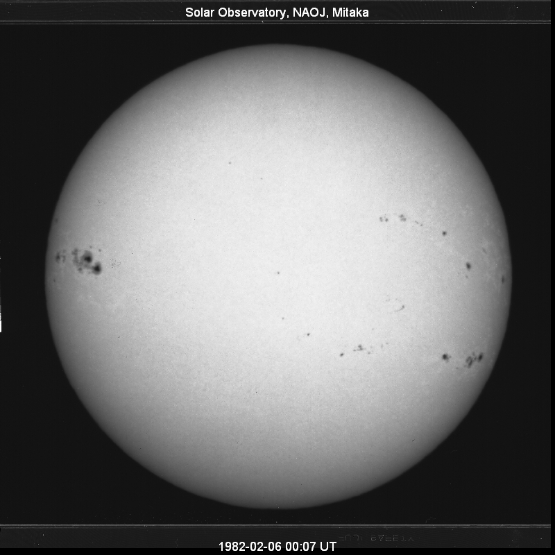
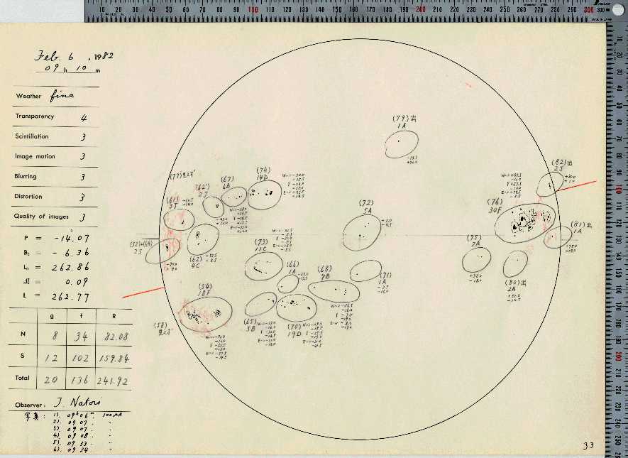
32 1982 2 6 2640 NOAA 3594 ■ ■
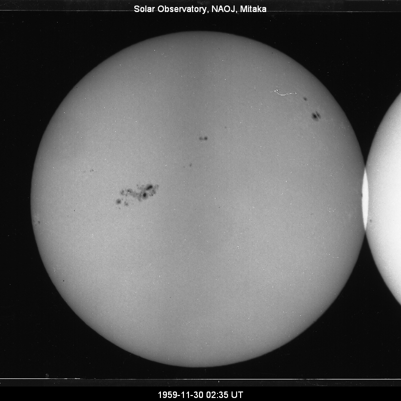
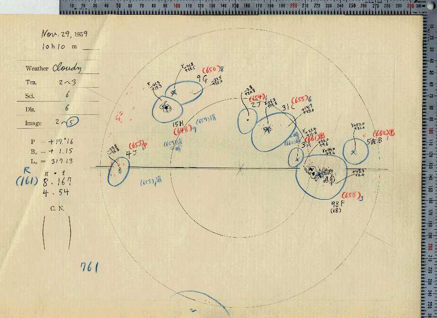
33 1959 11 29 2622 RGO 19651 ■ ■
34 1893 8 7 2621 RGO 3106 □ □
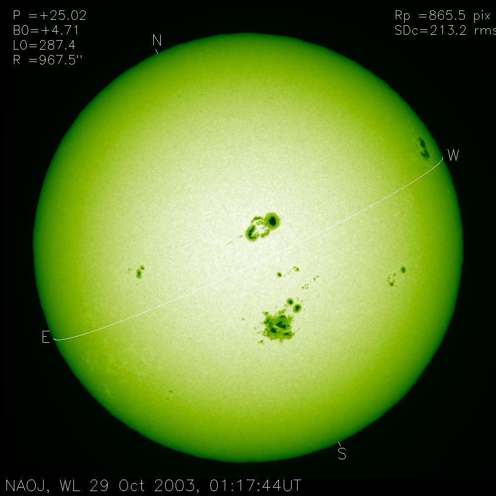
35 2003 10 29 2610 NOAA 10486 ■ ■
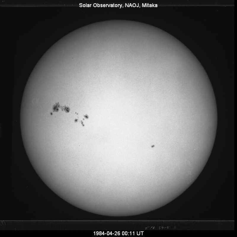
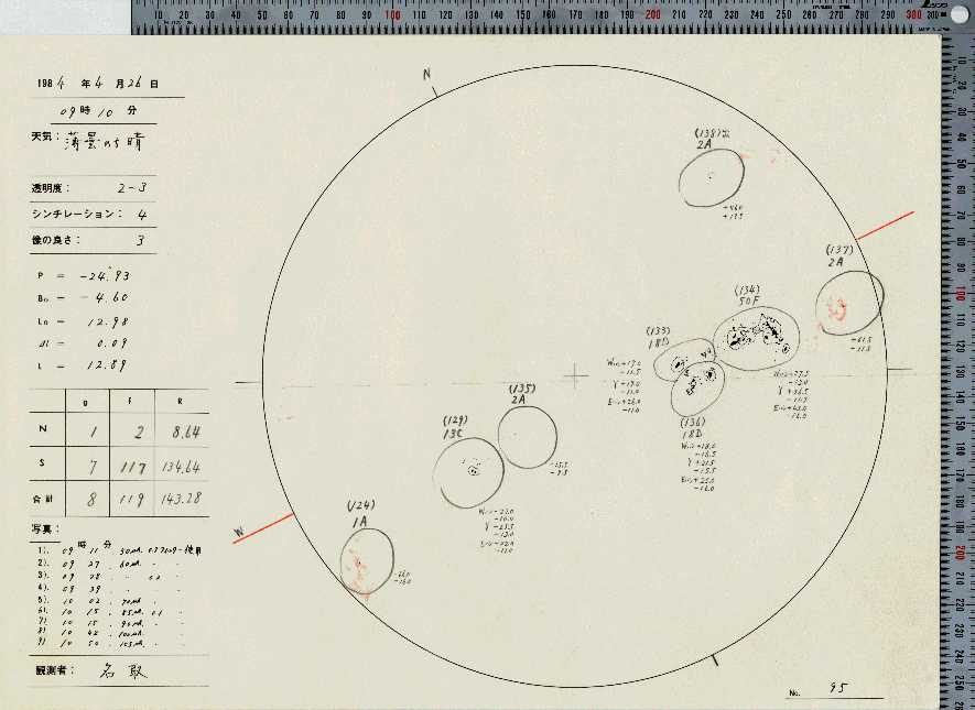
36 1984 4 26 2590 NOAA 4474 ■ ■
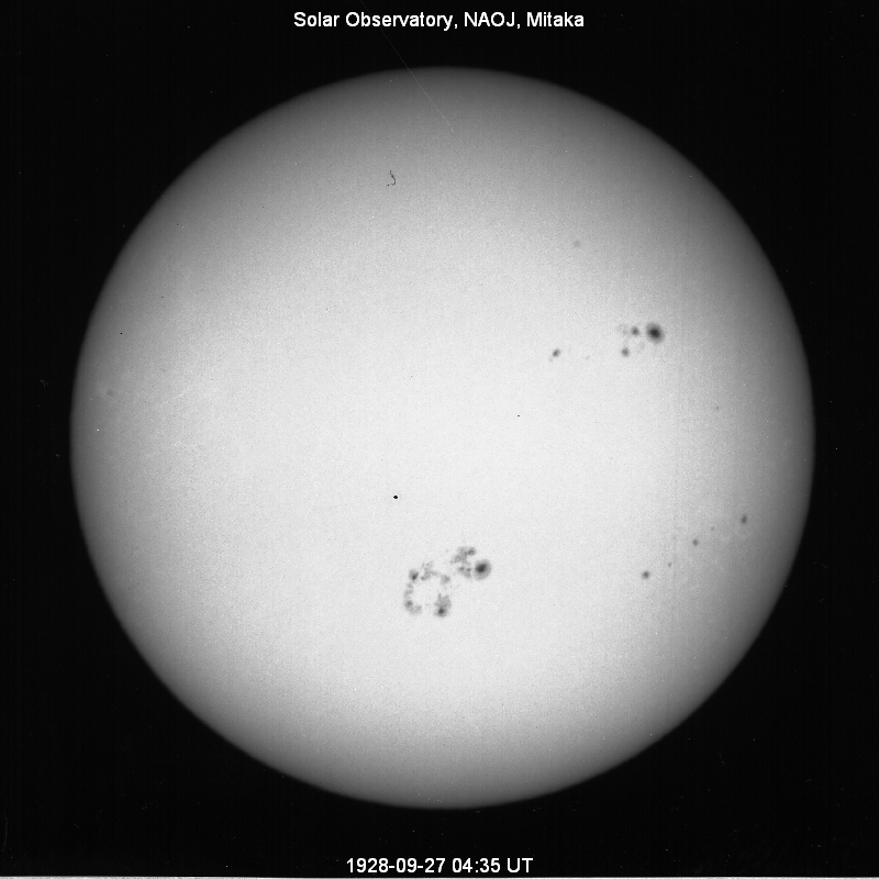
37 1928 9 27 2587 RGO 10746 ■ □
38 1905 3 7 2572 RGO 5473 □ □
39 1907 2 16 2555 RGO 6108 □ □
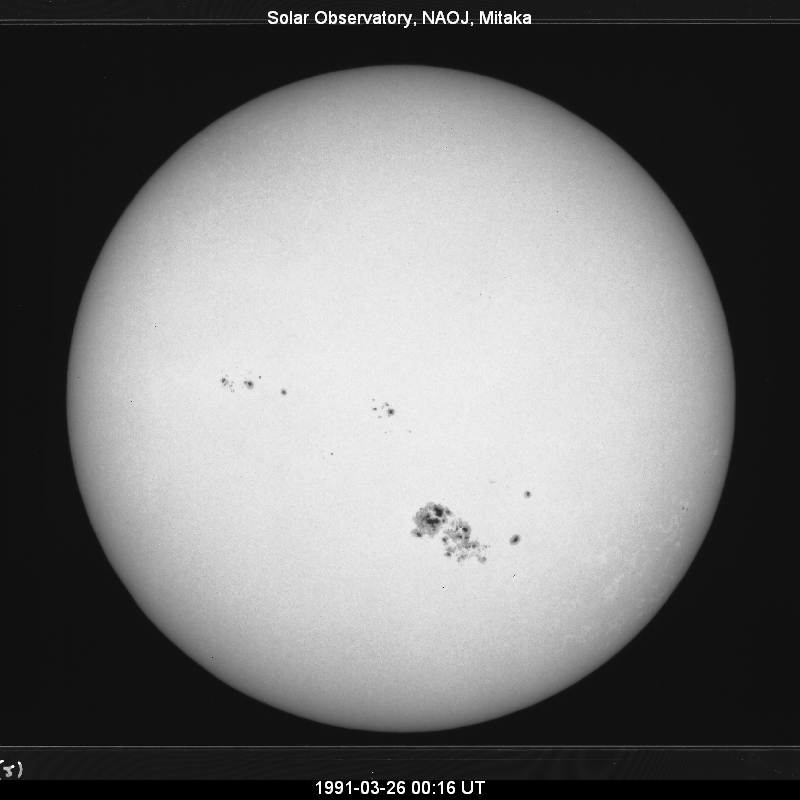
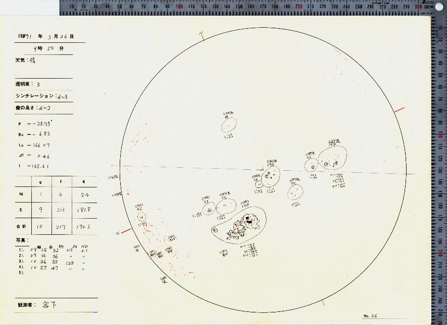
40 1991 3 25 2530 NOAA 6555 ■ ■
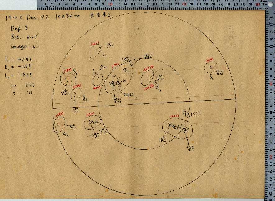
41 1948 12 26 2513 RGO 15831 □ ■
42 1894 10 5 2511 RGO 3731 □ □
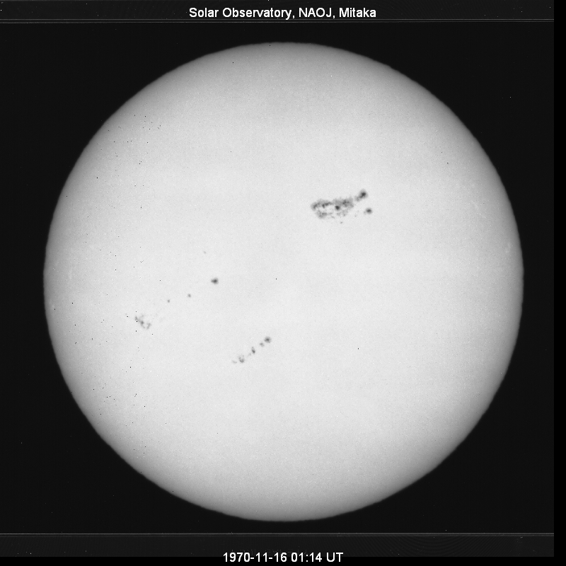
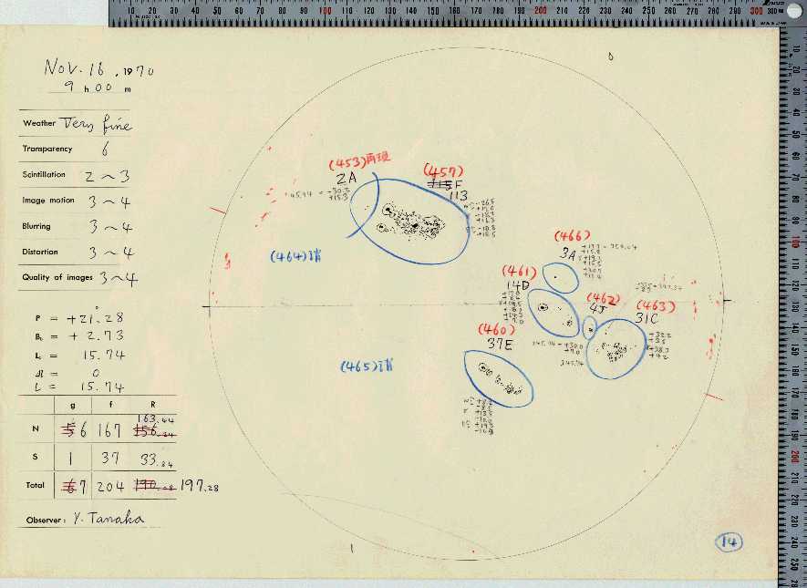
42 1970 11 17 2511 RGO 22605 ■ ■
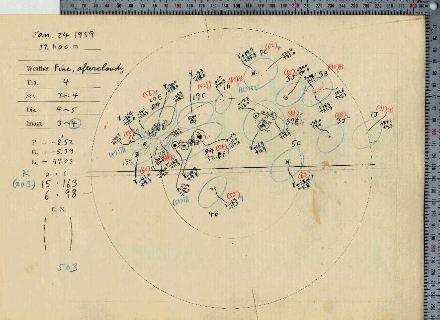
44 1959 1 24 2502 RGO 19140 ■ ■
□ means no data are available.
| Rank | Date of Maximum Area |
Area (MSH) |
Region Name | Note | Data I D |
|||
|---|---|---|---|---|---|---|---|---|
| 1 ( ( |
1947 1947 1947 |
4 3 2 |
8 12 10 |
6132 4554 2944 |
RGO RGO RGO |
14886 14851 14813 |
) one rotation before ) two rotations before |
□ ■ □ ■ □ ■ |
| 2 | 1946 | 2 | 7 | 5202 | RGO | 14417 | □ ■ | |
| 3 ( |
1951 1951 |
5 4 |
19 19 |
4865 2553 |
RGO RGO |
16763 16745 |
) one rotation before |
□ ■ □ ■ |
| 4 | 1946 | 7 | 29 | 4720 | RGO | 14585 | ■ ■ | |
| 5 ( |
1926 1925 |
1 12 |
19 31 |
3716 2934 |
RGO RGO |
9861 9830 |
) one rotation before |
■ □ ■ □ |
| 6 | 1938 | 1 | 21 | 3627 | RGO | 12673 | □ ■ | |
| 7 | 1989 | 3 | 17 | 3600 | NOAA | 5395 | ■ ■ | |
| 8 | 1917 | 2 | 14 | 3590 | RGO | 7977 | □ □ | |
| 9 | 1938 | 7 | 20 | 3379 | RGO | 12902 | ■ ■ | |
| 10 | 1937 | 10 | 5 | 3340 | RGO | 12553 | ■ □ | |
| 11 | 1905 | 2 | 2 | 3339 | RGO | 5441 | □ □ | |
| 12 | 1937 | 7 | 28 | 3303 | RGO | 12455 | ■ □ | |
| 13 | 1968 | 2 | 1 | 3202 | RGO | 21482 | ■ ■ | |
| 14 | 1917 | 8 | 9 | 3178 | RGO | 8181 | □ □ | |
| 15 ( |
1982 1982 |
6 7 |
14 12 |
3100 2870 |
NOAA NOAA |
3776 3804 |
) one rotation after |
■ ■ ■ ■ |
| 16 | 1941 | 9 | 21 | 3088 | RGO | 13937 | □ ■ | |
| 17 | 1989 | 9 | 3 | 3080 | NOAA | 5669 | ■ ■ | |
| 17 | 1990 | 11 | 18 | 3080 | NOAA | 6368 | ■ ■ | |
| 19 | 1939 | 9 | 6 | 3054 | RGO | 13394 | ■ ■ | |
| 20 | 1892 | 2 | 10 | 3038 | RGO | 2421 | □ □ | |
| 21 | 1938 | 10 | 12 | 3003 | RGO | 13024 | ■ ■ | |
| 22 | 1905 | 10 | 19 | 2995 | RGO | 5682 | □ □ | |
| 23 | 1939 | 9 | 13 | 2993 | RGO | 13405 | ■ ■ | |
| 24 | 1988 | 6 | 29 | 2900 | NOAA | 5060 | ■ ■ | |
| 25 | 1940 | 1 | 6 | 2860 | RGO | 13502 | □ ■ | |
| 26 | 1950 | 2 | 16 | 2856 | RGO | 16410 | □ ■ | |
| 27 | 1959 | 1 | 8 | 2805 | RGO | 19109 | ■ ■ | |
| 28 | 2014 | 10 | 26 | 2750 | NOAA | 12192 | ■ ■ | |
| 29 | 1897 | 1 | 8 | 2743 | RGO | 4497 | □ □ | |
| 30 | 1974 | 4 | 16 | 2706 | RGO | 23491 | ■ ■ | |
| 31 | 1920 | 3 | 23 | 2690 | RGO | 9143 | ■ □ | |
| 32 | 1982 | 2 | 6 | 2640 | NOAA | 3594 | ■ ■ | |
| 33 | 1959 | 11 | 29 | 2622 | RGO | 19651 | ■ ■ | |
| 34 | 1893 | 8 | 7 | 2621 | RGO | 3106 | □ □ | |
| 35 | 2003 | 10 | 29 | 2610 | NOAA | 10486 | ■ ■ | |
| 36 | 1984 | 4 | 26 | 2590 | NOAA | 4474 | ■ ■ | |
| 37 | 1928 | 9 | 27 | 2587 | RGO | 10746 | ■ □ | |
| 38 | 1905 | 3 | 7 | 2572 | RGO | 5473 | □ □ | |
| 39 | 1907 | 2 | 16 | 2555 | RGO | 6108 | □ □ | |
| 40 | 1991 | 3 | 25 | 2530 | NOAA | 6555 | ■ ■ | |
| 41 | 1948 | 12 | 26 | 2513 | RGO | 15831 | □ ■ | |
| 42 | 1894 | 10 | 5 | 2511 | RGO | 3731 | □ □ | |
| 42 | 1970 | 11 | 17 | 2511 | RGO | 22605 | ■ ■ | |
| 44 | 1959 | 1 | 24 | 2502 | RGO | 19140 | ■ ■ | |
Chronological Order
- In the 'Data' column, I means white-light images, D means sunspot drawings.
- ■ means an image or a drawing of the region is available. If no data are found on the day of maximum area, data of a nearby date are provided. The date will show up when the cursor is on the mark.
□ means no data are available.
Rank
Date of
Maximum Area
Area
(MSH)
Region Name
Note
Data
I D
20 1892 2 10 3038 RGO 2421 □ □
34 1893 8 7 2621 RGO 3106 □ □
42 1894 10 5 2511 RGO 3731 □ □
29 1897 1 8 2743 RGO 4497 □ □
11 1905 2 2 3339 RGO 5441 □ □
38 1905 3 7 2572 RGO 5473 □ □
22 1905 10 19 2995 RGO 5682 □ □
39 1907 2 16 2555 RGO 6108 □ □
8 1917 2 14 3590 RGO 7977 □ □
14 1917 8 9 3178 RGO 8181 □ □
31 1920 3 23 2690 RGO 9143 ■ □
(5
1925
1926
12
1
31
19
2934
3716
RGO
RGO
9830
9861
) one rotation before
■ □
■ □
37 1928 9 27 2587 RGO 10746 ■ □
12 1937 7 28 3303 RGO 12455 ■ □
10 1937 10 5 3340 RGO 12553 ■ □
6 1938 1 21 3627 RGO 12673 □ ■
9 1938 7 20 3379 RGO 12902 ■ ■
21 1938 10 12 3003 RGO 13024 ■ ■
19 1939 9 6 3054 RGO 13394 ■ ■
23 1939 9 13 2993 RGO 13405 ■ ■
25 1940 1 6 2860 RGO 13502 □ ■
16 1941 9 21 3088 RGO 13937 □ ■
2 1946 2 7 5202 RGO 14417 □ ■
4 1946 7 29 4720 RGO 14585 ■ ■
(
(1
1947
1947
1947
2
3
4
10
12
8
2944
4554
6132
RGO
RGO
RGO
14813
14851
14886
) two rotations before
) one rotation before
□ ■
□ ■
□ ■
41 1948 12 26 2513 RGO 15831 □ ■
26 1950 2 16 2856 RGO 16410 □ ■
(3
1951
1951
4
5
19
19
2553
4865
RGO
RGO
16745
16763
) one rotation before
□ ■
□ ■
27 1959 1 8 2805 RGO 19109 ■ ■
44 1959 1 24 2502 RGO 19140 ■ ■
33 1959 11 29 2622 RGO 19651 ■ ■
13 1968 2 1 3202 RGO 21482 ■ ■
42 1970 11 17 2511 RGO 22605 ■ ■
30 1974 4 16 2706 RGO 23491 ■ ■
32 1982 2 6 2640 NOAA 3594 ■ ■
15
(
1982
1982
6
7
14
12
3100
2870
NOAA
NOAA
3776
3804
) one rotation after■ ■
■ ■
36 1984 4 26 2590 NOAA 4474 ■ ■
24 1988 6 29 2900 NOAA 5060 ■ ■
7 1989 3 17 3600 NOAA 5395 ■ ■
17 1989 9 3 3080 NOAA 5669 ■ ■
17 1990 11 18 3080 NOAA 6368 ■ ■
40 1991 3 25 2530 NOAA 6555 ■ ■
35 2003 10 29 2610 NOAA 10486 ■ ■
28 2014 10 26 2750 NOAA 12192 ■ ■
□ means no data are available.
| Rank | Date of Maximum Area |
Area (MSH) |
Region Name | Note | Data I D |
|||
|---|---|---|---|---|---|---|---|---|
| 20 | 1892 | 2 | 10 | 3038 | RGO | 2421 | □ □ | |
| 34 | 1893 | 8 | 7 | 2621 | RGO | 3106 | □ □ | |
| 42 | 1894 | 10 | 5 | 2511 | RGO | 3731 | □ □ | |
| 29 | 1897 | 1 | 8 | 2743 | RGO | 4497 | □ □ | |
| 11 | 1905 | 2 | 2 | 3339 | RGO | 5441 | □ □ | |
| 38 | 1905 | 3 | 7 | 2572 | RGO | 5473 | □ □ | |
| 22 | 1905 | 10 | 19 | 2995 | RGO | 5682 | □ □ | |
| 39 | 1907 | 2 | 16 | 2555 | RGO | 6108 | □ □ | |
| 8 | 1917 | 2 | 14 | 3590 | RGO | 7977 | □ □ | |
| 14 | 1917 | 8 | 9 | 3178 | RGO | 8181 | □ □ | |
| 31 | 1920 | 3 | 23 | 2690 | RGO | 9143 | ■ □ | |
( 5 |
1925 1926 |
12 1 |
31 19 |
2934 3716 |
RGO RGO |
9830 9861 |
) one rotation before |
■ □ ■ □ |
| 37 | 1928 | 9 | 27 | 2587 | RGO | 10746 | ■ □ | |
| 12 | 1937 | 7 | 28 | 3303 | RGO | 12455 | ■ □ | |
| 10 | 1937 | 10 | 5 | 3340 | RGO | 12553 | ■ □ | |
| 6 | 1938 | 1 | 21 | 3627 | RGO | 12673 | □ ■ | |
| 9 | 1938 | 7 | 20 | 3379 | RGO | 12902 | ■ ■ | |
| 21 | 1938 | 10 | 12 | 3003 | RGO | 13024 | ■ ■ | |
| 19 | 1939 | 9 | 6 | 3054 | RGO | 13394 | ■ ■ | |
| 23 | 1939 | 9 | 13 | 2993 | RGO | 13405 | ■ ■ | |
| 25 | 1940 | 1 | 6 | 2860 | RGO | 13502 | □ ■ | |
| 16 | 1941 | 9 | 21 | 3088 | RGO | 13937 | □ ■ | |
| 2 | 1946 | 2 | 7 | 5202 | RGO | 14417 | □ ■ | |
| 4 | 1946 | 7 | 29 | 4720 | RGO | 14585 | ■ ■ | |
( 1( |
1947 1947 1947 |
2 3 4 |
10 12 8 |
2944 4554 6132 |
RGO RGO RGO |
14813 14851 14886 |
) two rotations before ) one rotation before |
□ ■ □ ■ □ ■ |
| 41 | 1948 | 12 | 26 | 2513 | RGO | 15831 | □ ■ | |
| 26 | 1950 | 2 | 16 | 2856 | RGO | 16410 | □ ■ | |
( 3 |
1951 1951 |
4 5 |
19 19 |
2553 4865 |
RGO RGO |
16745 16763 |
) one rotation before | □ ■ □ ■ |
| 27 | 1959 | 1 | 8 | 2805 | RGO | 19109 | ■ ■ | |
| 44 | 1959 | 1 | 24 | 2502 | RGO | 19140 | ■ ■ | |
| 33 | 1959 | 11 | 29 | 2622 | RGO | 19651 | ■ ■ | |
| 13 | 1968 | 2 | 1 | 3202 | RGO | 21482 | ■ ■ | |
| 42 | 1970 | 11 | 17 | 2511 | RGO | 22605 | ■ ■ | |
| 30 | 1974 | 4 | 16 | 2706 | RGO | 23491 | ■ ■ | |
| 32 | 1982 | 2 | 6 | 2640 | NOAA | 3594 | ■ ■ | |
| 15 ( |
1982 1982 |
6 7 |
14 12 |
3100 2870 |
NOAA NOAA |
3776 3804 |
) one rotation after |
■ ■ ■ ■ |
| 36 | 1984 | 4 | 26 | 2590 | NOAA | 4474 | ■ ■ | |
| 24 | 1988 | 6 | 29 | 2900 | NOAA | 5060 | ■ ■ | |
| 7 | 1989 | 3 | 17 | 3600 | NOAA | 5395 | ■ ■ | |
| 17 | 1989 | 9 | 3 | 3080 | NOAA | 5669 | ■ ■ | |
| 17 | 1990 | 11 | 18 | 3080 | NOAA | 6368 | ■ ■ | |
| 40 | 1991 | 3 | 25 | 2530 | NOAA | 6555 | ■ ■ | |
| 35 | 2003 | 10 | 29 | 2610 | NOAA | 10486 | ■ ■ | |
| 28 | 2014 | 10 | 26 | 2750 | NOAA | 12192 | ■ ■ | |